Sudan Volcanoes
-

Bayuda Volcanic Field
-
Meidob Volcanic Field
-
Bayuda Volcanic Field
-
Meidob Volcanic Field
-
Jebel Marra
-
Bayuda Volcanic Field
-
Bayuda Volcanic Field
-
Jebel Marra
-

Kutum Volcanic Field
Sudan has 4 Holocene volcanoes. Note that as a scientific organization we provide these listings for informational purposes only, with no international legal or policy implications. Volcanoes will be included on this list if they are within the boundaries of a country, on a shared boundary or area, in a remote territory, or within a maritime Exclusive Economic Zone. Bolded volcanoes have erupted within the past 20 years. Suggestions and data updates are always welcome ().
| Volcano Name | Location | Last Eruption | Primary Volcano Type |
|---|---|---|---|
| Bayuda Volcanic Field | Sudan | 850 CE | Volcanic field |
| Kutum Volcanic Field | Sudan | Unknown - Evidence Uncertain | Volcanic field |
| Jebel Marra | Sudan | 2000 BCE | Volcanic field |
| Meidob Volcanic Field | Sudan | 2950 BCE | Volcanic field |
Chronological listing of known Holocene eruptions (confirmed or uncertain) from volcanoes in Sudan. Bolded eruptions indicate continuing activity.
| Volcano Name | Start Date | Stop Date | Certainty | VEI | Evidence |
|---|---|---|---|---|---|
| Bayuda Volcanic Field | 0850 ± 50 years | Unknown | Confirmed | Isotopic: 14C (uncalibrated) | |
| Jebel Marra | 2000 BCE (?) | Unknown | Confirmed | 4 | Isotopic: 14C (calibrated) |
| Meidob Volcanic Field | 2950 BCE ± 500 years | Unknown | Confirmed | 0 | Radiogenic: Thermoluminescence |
| Meidob Volcanic Field | 3000 BCE (?) | Unknown | Confirmed | 4 | Correlation: Tephrochronology |
| Meidob Volcanic Field | 3050 BCE (?) | Unknown | Confirmed | 4 | Correlation: Tephrochronology |
| Meidob Volcanic Field | 4150 BCE ± 1450 years | Unknown | Confirmed | 4 | Correlation: Tephrochronology |
| Meidob Volcanic Field | 5250 BCE ± 500 years | Unknown | Confirmed | Radiogenic: Thermoluminescence | |
| Meidob Volcanic Field | 6050 BCE ± 1600 years | Unknown | Confirmed | 4 | Radiogenic: Thermoluminescence |
Sudan has 0 Pleistocene volcanoes. Note that as a scientific organization we provide these listings for informational purposes only, with no international legal or policy implications. Volcanoes will be included on this list if they are within the boundaries of a country, on a shared boundary or area, in a remote territory, or within a maritime Exclusive Economic Zone. Suggestions and data updates are always welcome ().
There are 9 photos available for volcanoes in Sudan.
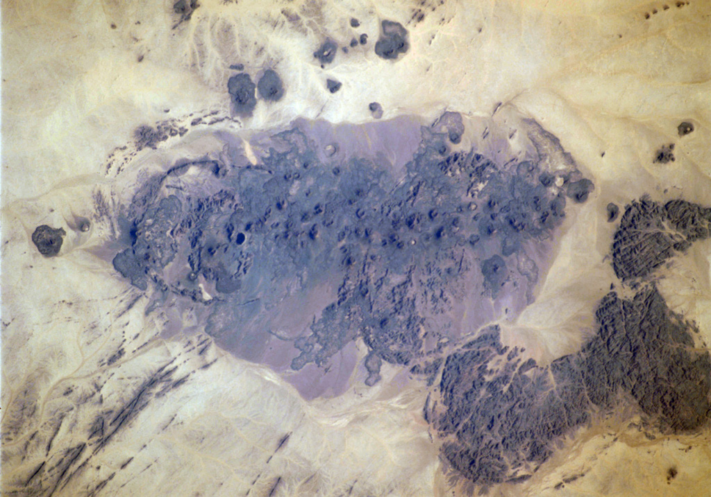
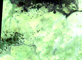
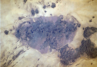
 The dark-colored area in the center of this Space Shuttle view is the alkaline Meidob volcanic field in western Sudan. This broad volcanic field covers an area of 5,000 km2 with nearly 700 Pliocene-to-Holocene vents. The margins of the field are dominated by basaltic scoria cones and associated lava flows, but the lava domes, tuff rings, and maars that are concentrated along the central E-W-trending axis of the volcanic field are among the youngest features. The latest dated eruptions took place about 5,000 years ago.
NASA Space Shuttle image STS073-713-87, 1995 (http://eol.jsc.nasa.gov/).
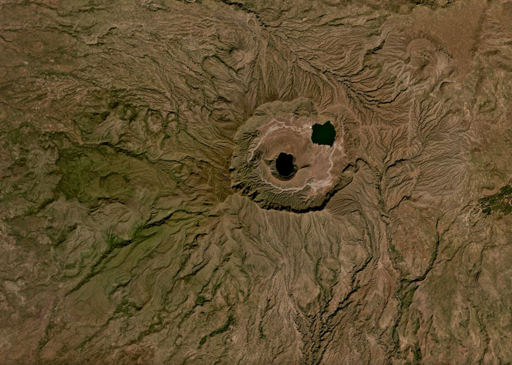
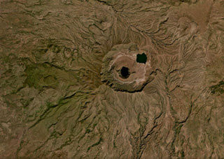 The 5-7 km Deriba caldera is part of the Jebel Marra volcanic field, located in the Darfur province of western Sudan, shown in this November 2019 Planet Labs satellite image monthly mosaic (N is at the top). It formed during an eruption 3,500 years ago that produced pyroclastic flows reaching 30 km away. The central lake is within the crater of a smaller cone.
Satellite image courtesy of Planet Labs Inc., 2019 (https://www.planet.com/).
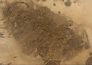 The 480 km2 Bayuda Volcanic Field in Sudan contains around 70 small volcanic centers including at least 53 scoria cones and 15 maar craters, shown in this November 2019 Planet Labs satellite image monthly mosaic (N is at the top; this image is approximately 46 km across). The field was partly constructed over Precambrian and Paleozoic granite, which form darker areas to the SE.
Satellite image courtesy of Planet Labs Inc., 2019 (https://www.planet.com/).
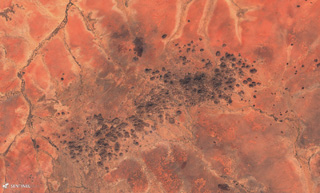
 The scattered cones of the Kutum basaltic volcanic field (lower left) in the northern Dafur area of western Sudan are located SW of the larger Meidob volcanic field (top). As with other Saharan volcanic fields, Kutum (also known as the Tagabo Hills) contains very well-preserved cones, lava flows, and craters, although their ages are not well constrained.
NASA Landsat image, 1999 (courtesy of Hawaii Synergy Project, Univ. of Hawaii Institute of Geophysics & Planetology).
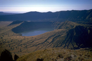 A lake partially fills a younger cone within the Deriba caldera of Jebel Marra volcano in this view from the N. The 5-km-wide, steep-walled caldera, whose wall appears in the background, was formed about 3,500 years ago at the time of the eruption of voluminous airfall pumice and pyroclastic flows that traveled more than 30 km from the volcano. Post-caldera ash eruptions may have continued into historical time.
Photo by J. Williams, 1986 (http://en.wikipedia.org/wiki/Image:Sudan_Jebel_Marra_Deriba_Lakes.jpg)
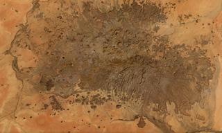 The Meidob Volcanic Field covers approximately 5,000 km2 in western Sudan, seen in this November 2019 Planet Labs satellite image monthly mosaic (N is at the top; this image is approximately 100 km across). Around 700 features have been identified, including scoria cones, maars, tuff rings, and eroded features. Some lava flows reached more than 20 km from their source.
Satellite image courtesy of Planet Labs Inc., 2019 (https://www.planet.com/).
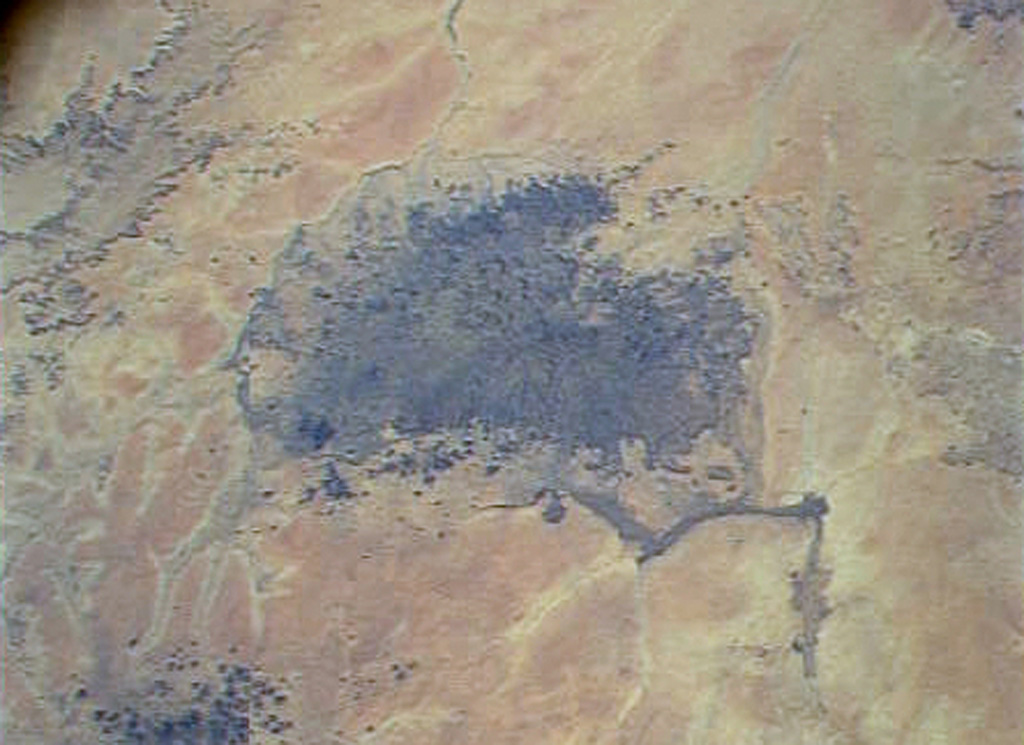
 The Bayuda volcanic field is located near the center of the Bayuda desert of NE Sudan. The numerous small scoria cones that trend horizontally across the center of the volcanic field in this International Space Station image were erupted along a WNW-trending line. Lava flows, one of which was erupted about 1,100 years ago, are visible in this image, but about 10% of the vents are craters. Bayuda was constructed over Precambrian and Paleozoic granitic rocks, which form the darker areas at the lower right.
NASA International Space Station image ISS004-711-20, 2002 (http://eol.jsc.nasa.gov/).
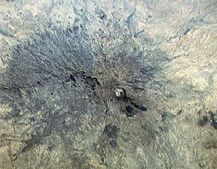 The small circular area just right of the center of this Space Shuttle image is Deriba caldera, the most prominent feature of the vast Jebel Marra volcanic field in western Sudan. The 5-km-wide, steep-walled caldera was formed about 3,500 years ago during an eruption that produced voluminous airfall pumice and pyroclastic flows that traveled more than 30 km from the volcano. Ash eruptions may have continued into early historical time, and fumarolic activity continues on the flanks of the caldera.
NASA Space Shuttle image STS32-94-24, 1990 (http://eol.jsc.nasa.gov/).
 The Kutum Volcanic Field contains many scoria cones, craters, and lava flows, seen in this 25 November 2019 Sentinel-2 satellite image (N is at the top). This image is approximately 85 km across, and is south of the larger Meidob volcanic field.
Satellite image courtesy of Copernicus Sentinel Data, 2019.
This is a compilation of Sudan volcano information sources, such as official monitoring or other government agencies.
| Volcanic Ash Advisory Center | |
|---|---|
| Toulouse Volcanic Ash Advisory Center (VAAC) Notices and Archive | |